

Humanitarian Assistance and Disaster Relief Systems
We use our experience developing sensors and decision support software to build systems that are used around the world for coordinating responses to wildfires, aiding urban search-and-rescue missions, assessing damage after hurricanes and earthquakes, and planning for large-scale evacuations. We work closely with local, state, and federal agencies to develop these systems. Our goal is to enable responders to more effectively gain situational awareness, share information, and make decisions in times of crisis. We also prototype technologies, such as communication hubs and solar-powered resources, to aid disaster survivors and refugee populations. Many of our programs involve collaboration across Laboratory groups whose technologies can be applied to disaster and humanitarian missions.
Featured Projects
disaster relief
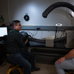
Vine Robots for Collapsed Structure Mapping
These robots can navigate difficult urban disaster terrain to help responders locate and access victims for rescue.

disaster relief
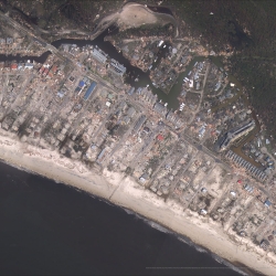
Multi-label Dataset and Classifiers for Low-Altitude Disaster Imagery
This software program helps disaster responders extract actionable information from post-disaster aerial images.
sensing
Private Automated Contact Tracing
An automated, Bluetooth-based system helps perform contact tracing in a private, anonymous way, offering a method to reduce disease spread during a pandemic.
disaster relief
DisasterSat
Dedicated satellite imaging could help coordinate emergency response to disasters.

Climate modeling / impact prediction / adaptation
Climate Resilience Early Warning System Network
We are creating proactive, integrated decision -support tools and services that empower frontline communities to prepare for climate impacts and minimize losses.
Latest News


Laboratory Stories
I find inspiration in the people around me.
Nathaniel Hanson
Robotics and Remote Sensing Engineer
Biotechnology and Human Systems
Humanitarian Assistance and Disaster Relief Systems

I am always looking for ways to make the lives of my teammates easier and make the survivor experience better.
Chad Council
Systems Analyst
Biotechnology and Human Systems
Humanitarian Assistance and Disaster Relief Systems

Advancing Our Research
Featured Publications
Automated exposure notification for COVID-19
Feb 14
MIT Lincoln Laboratory Report TR-1288
Development and validation of the public-facing SimAEN web application
Aug 1
MIT Lincoln Laboratory Report ACTA-6
Fun as a strategic advantage: applying lessons in engagement from commercial games to military logistics training
Jul 1
Train., Educ., Learn. Sci., Vol. 59, 2022, p. 180-7.